
OZ Metro Web Mapping Services
Open Source
Intuitive User Interface
Streaming Data Capability
No Software License or Installations Necessary
Accessible on Multiple Browsers/Interfaces
Offered in Two versions -
OZ Metro Standard
OZ Metro Lite
OZ Metro Standard has full database functionality

OZ Metro Web Mapping Services
Metro Planning, Inc. introduces OZ Metro: an open source, low cost way to display Geographical Information Systems (GIS) data quickly and easily on the web.
OZ Metro was developed in response to a need by local government agencies to share collected sets of GIS data as part of regional, and multi-jurisdictional planning efforts.
Data gathered from a variety of sources, along with the GIS analytical output created during the project would often remain locked away from stake holders. Initial efforts to share this data involved using free GIS software such as Arc Explorer or Map Windows. But these solutions required the user to install the software and data on their local PC which quickly became problematic.
We realized that a browser-based solution for providing GIS data to the end user was a better approach. With OZ Metro, data can be more easily shared, more quickly updated, and effectively integrated with a variety of other data sources. The only software requirement for the end user is access to a familiar web browser, such as Internet Explorer or Firefox.
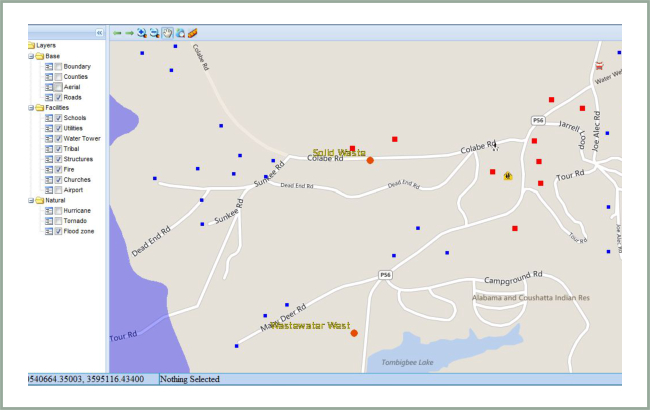
Metro Planning's goal in creating a GIS Web mapping application was that it be simple to use and allow a maximum area for the map display. As such, Metro Planning has created an intuitive user interface, capable of handling data in a variety of formats. OZ Metro includes the ability to integrate client data in an organized fashion within a user-defined, interactive layer tree. Familiar tools, along with collapsible panels, and tabbed functional groups, allow the user to create the best mapping experience for themselves.
OZ Metro also features streaming data capability from web mapping services (WMS) such as Bing, Google, and a variety of state and other open source data services. All this is done with the best possible combination of Open Source mapping and data base products. OZ Metro is based on Open Source products chosen by Metro Planning after doing extensive research on the variety of GIS-related Open Source software.
Contact Us
- Open Source
- Intuitive User Interface
- Streaming Data Capability
- No Software License or Installations Necessary
- Accessible on Multiple Browsers/Interfaces
- Offered in Two versions -
- OZ Metro Standard has full database functionality
OZ Metro Standard
OZ Metro Lite